Ezra Boyd---Declarations of the death of an American city have given way to new reasons to be optimistic about New Orleans’ future. Anyone who has visited the city recently will tell you that the metro area is well into a robust period of re-population and recovery.
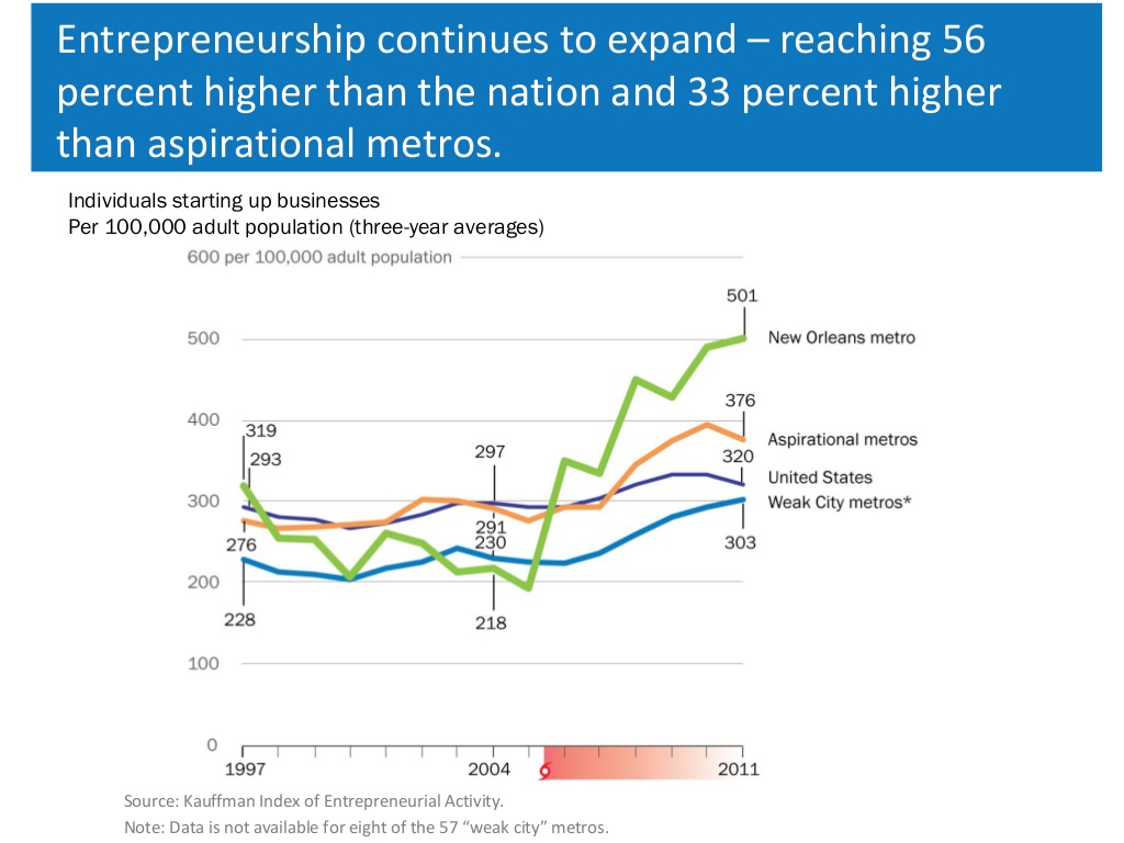 Source: GNOCDC New Orleans Index and Kauffman Index of Entrepreneurial Activity -Click pic to enlarge-
The numbers support this view. New Orleans itself has regained 80% of it’s pre-flood population, while the larger metropolitan region has regained over 90% of it’s population. A strong recovery has fueled a strong economy, and the tech sector in particular has gained national prominence. While the neighborhoods continue to recover, the federal, state, and local governments have vigorously invested in improved flood protection and coastal restoration. The Corps has spent $15 billion in structural projects, while local governments across the region continue to invest in levees, wetlands, and home raising. At the state level, Louisiana’s ambitious $50 billion 2012 Coastal Master Plan has identified projects that contribute to multiple lines of defense for the coastal region. While these positive signs have been covered extensively, this article examines another reason for optimism that has not gotten as much attention, but could prove to be the saving grace: Climate trends.
 In particular, there are early signs that the North Atlantic Oscillation (NAO)and the Atlantic Multidecadal Oscillation (AMO) could be entering the end of the recent period that spawned the memorable gulf coast storms of recent years. The AMO is a climate trend in the North Atlantic ocean that influences the frequency and severity of hurricanes in the Atlantic basin, while the NAO is a similar climate trend that influences the paths that hurricanes follow. It is one of several periodic global climate trends, similar to the El Niño Southern Oscillation (ENSO). In general, periodic climate trends follow somewhat regular temporal patterns in severity, with a peak and a low point which are separated by many years. Climate studies have found that NAO influences hurricane activity … specifically along the Gulf coast. Generally speaking the high activity periods last for about 15 years and are separated by 30 years of low activity.
There is one caveat to keep in mind, human induced global warming and sea level rise will almost certainly influence the NAO and AMO trends, specifically in terms of the both intensity and duration of the peaks. Indeed, we ran our post by Dr. Jeff Masters at Wunderblog, and he promptly, kindly replied: “The proper pattern to refer to is the Atlantic Multidecadal Oscillaion (AMO), which entered a positive phase in 1995, launching our current active hurricane period.While the NAO is important for steering hurricanes, it is not important for influencing the total number of hurricanes, nor how strong they get. Since the AMO is tied to sea surface temperatures (SSTs), and SSTs were above average in the tropical Atlantic again this year, I think it is unlikely that we are seeing early signs of an end to the active AMO period that began in 1995. The inactivity this year was due to atmospheric circulation patterns that brought much dry air to the tropical Atlantic.”
The last 20 or so years have certainly been a period of high activity in the Atlantic basin and specifically in the Gulf of Mexico. Starting with Hurricane Andrew in 1992, the peak period of the NAO also includes many memorable storms: Georges (1998), Ivan (2004),Katrina (2005), Rita (2005), Ike (2008), and Isaac (2012). Of note, if you take 1992 as the start of the peak period, we are now 21 years into that peak period. Going back into recent history, the previous peak period of high hurricane activity consists of Hurricane Audrey in 1957 which killed over 400 in southwest Louisiana, Hurricane Betsy (1965) which caused levee breaches in the Industrial Canal and caused 75 deaths in Louisiana, and Hurricane Camille(1969) which was similar to Hurricane Katrina in intensity and killed over 250 along the Mississippi Gulf Coast. After enduring the 12 years of devastation between Audrey and Camille, the Gulf coast breathed a sigh of relief as the low period in the NAO meant no major storm impacts for almost 30 years between 1969-98.
What will the next 20 to 30 years for the Gulf coast be like? This year could be some indication. Despite predictions of high hurricane activity in the Atlantic basin, the year included no major storms in the Atlantic or Gulf of Mexico. Just two storms, Tropical Storms Audrea and Karen, took aim for coastal Louisiana at some point. However, in both cases the storms were sheared apart by a jet stream that extended south over Louisiana and that sent most of their remaining moisture to Alabama and Mississippi.
Other storms either followed tracks across the southern Gulf of Mexico or up the Atlantic coast. While the 2012 Hurricane season certainly generated memorable events along with widespread devastation in Southeast Louisiana, it is important to keep in mind that Hurricane Isaac was not a strong storm. It was a slow moving storm with a track that exploited the vulnerabilities of Louisiana declining coast.

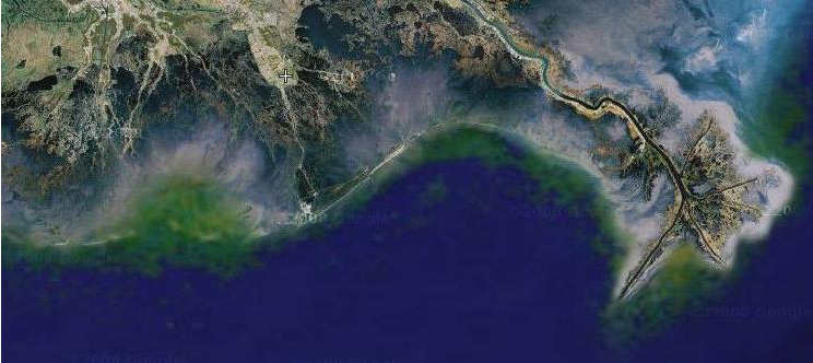
Source: LSU Earth Scan Laboratory -Click pic to enlarge
While it is difficult to predict trends in the complex atmospheric dynamics that influence hurricanes, their strengths, and their intensities, the available data does support the notion that the NAO is entering a possible 30 year period of lower hurricane activity in the Gulf of Mexico. If so, this period provides a unique and important window to finish our recovery and build upon the momentum toward enhancing protection and fostering mitigation. It also potentially provides a period to implement important coastal restoration projects, such as those in the Louisiana Master Plan.
However, there are also two lessons to keep in mind. One, global warming and sea level rise could change everything that we think we have learned about climate trends. And, two, during the last period of calm we focused on just structural protection through levees, floodgates, and pump stations. We made a fatal error in neglecting measures to enhance coastal and community resiliency. When the peak of last NAO cycle brought Hurricane Katrina, this error taught us a powerful lesson that focusing on just structural protection was a mistake. Even though many of engineering shortcomings have been addressed, the catastrophic levee failures of 2005 can happen again.
To reinforce that lesson, Hurricane Isaac was not a strong storm. Rather, it was a deadly and destructive storm partially because it’s path produced a storm surge in areas where our coast had lost its resilience due to erosion and wetland loss. Perhaps, the biggest lesson from Hurricane Isaac is that we cannot repeat this mistake during the next 30 year period of potentially low activity.
~Dr. Ezra Boyd, is a hazards geographer, disaster scientists and co-founder of DisasterMap.net, which provides real time disaster monitoring along with consulting in risk analysis and hazards geography. Prior to launching this business, he worked with the Lake Pontchartrain Basin Foundation as a coastal scientist and GIS specialist. At the Basin Foundation, his major projects include the Multiple Lines of Defense Strategy for flood protection for greater New Orleans, monitoring and assessing the impacts of the 2012 BP Oil Well Blowout, the Bohemia Spillway, and Mardi Gras Pass, an emerging distributary of the Mississippi River. His research on the preparations, response, and impacts of Hurricane Katrina has been published in Risk Analysis; Public Performance and Management Review; Risk, Hazards, and Crisis in Public Policy; and the International Journal of Systems Biology and Biomedical Technologies. An upcoming article in the Journal of Emergency Management will describe a coordinated surveillance program in response to the 2010 BP Oil Well Blowout. In 2011, he earned his Ph.D. in geography with a minor in disaster science and management from Louisiana State University. His dissertation presented a comprehensive assessment and analysis of deaths associated with Hurricane Katrina and the catastrophic failure of the Federal levee system for southeast Louisiana.. While at LSU, he participated in the Team Louisiana report for the Louisiana Department of Transportation and Development and co-authored the Health Care and Disaster Planning book for the Louisiana State Medical Society.
~Special thanks to Dr. Jeff Masters at Wunderblog for his prompt response, helping us better understand the Atlantic Multidecadal Oscillation and Climate Trends.
No comments:
Post a Comment
Say something constructive. Negative remarks and name-calling are not allowed.